One of our aircraft directions is aerogeophysical surveys. This article is not about the shooting themselves, but about aircraft, which we use for this type of work and their advantages over large aviation and before the UAV.
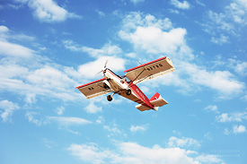
The SP-38 aircraft is a ultralight civil aircraft suitable for out-aroder use. This is one of the advantages over the great aviation. Length of running out 200 m significantly facilitates the search for the runway. The plane is unpretentious to its quality (the region of the country road does not exist with ruts).
The second advantage is fuel. SP-38 uses an easily accessible automotive gasoline of the brand 95 as fuel. It can be found in any corner of the country. Fuel consumption is an order of magnitude lower than that of great aviation. Great aviation flies on more expensive types of fuel: aviation kerosene, aviation gasoline B-91 or LL100.
And the third advantage over large aviation is the height of the flight. Work 15 meters above the surface of the Earth (or forest vegetation) with the general rope envelope is the norm for this type of aircraft.
As for the CAPP, there are also a number of advantages. The first is still manned aircraft and all work are made in one pass, without prior examination of the area and create a flight program. Second – lifting capacity. Our aircraft, although small, but are practically the same equipment as great aviation. While the UAV can take on board only light devices with a lower resolution.
Thus, using a ultralight aircraft, we get an airplane with the advantages of both great aviation and the UAV: the ability to wear high-resolution filming equipment, like a large aviation, and at the same time flying at low altitudes, with the general cutting of the relief as CAPP.
The design features of the SP-38 aircraft and the engineering potential of our company allowed us to implement the following important points:
- aircraft used for airborne geophysical surveys are maximally freed from magnetic materials, which makes it possible to reduce noise affecting the magnetometer sensors.
- the aircraft are equipped with light plastic containers for geophysical instruments, harmoniously integrated into the structural and aerodynamic scheme. These engineering solutions are calculated, tested and approved by the authorized certification bodies of the Federal Air Transport Agency. Their use allows the installation of equipment very quickly (from the beginning of the installation process to the start-up of the equipment it takes only a few hours), as well as safely and efficiently perform aerial survey flights.
- on our aircraft, a vertical and horizontal magnetometric gradiometer is implemented: up to four sensors simultaneously.
A list of full-size aircraft geophysical equipment of high resolution, which can be placed on the aircraft SP-38 for geophysical works:
- magnetometric complex using up to 4 Scintrex SC-3 sensors simultaneously;
- aircraft gamma spectrometer RSX-4, Exploranium;
- gravimeter TAGS-7;
- aviation lidar for creating a 3D terrain model;
Possible options for integrating aerial survey work:
- Gamma-spectrometric and magnetic surveys.
- Gravica and magnetic surveys and lidar.
Our aircraft are certified to use the geophysical equipment listed. And the presence of a certificate and technology for the use of this equipment gives permission to perform aerial survey geophysical works, which is confirmed by the operator’s certificate issued by the Federal Air Transport Agency.
* this page has been translated automatically


